Mixture Model
The
Mixture
Model is
a component that implements a raster
decomposition
using the mixture model
strategy. The spatial resolution of remote sensing satellites, in
general, allows that a single pixel contains more than a target
(for
example vegetation + shadow + soil). The mixture model algorithms
allow
to decompose the raster into fraction images, where the value of
the
resultant pixels indicate the fraction of each target inside the
pixel.
The main
information needed to execute a mixture model are:
- A map of pure endmembers,
which are pixel values where the user knows the exact proportion
of a
component.
- Sensor information for each
band, if available
The
available methods in TerraLib
are:
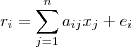
- Linear (Least Square Method):
It is calculated
by the following equation:
- ri
is the pixel value at band i,
- aij
is the known value of the
component j
at band i,
- xj
is the proportion
of component j,
- ei
is the estimation error for band i.
- Linear (Resticted Least
Square Method (only 3 components, 4 bands): It is
calculated
by the same equation above but with a additional restriction
over the fraction values.
Reference: Modelo Linear de Mistura Espectral Conceitos
Teóricos, Algoritmos e Aplicações em Estudos na Amazônia Legal
Linear Spectral Mixing Model, Theoretical Concepts, Algorithms
and Applications in Studies in the Legal Amazon, Yosio Edemir
Shimabukuro , Andeise Cerqueira Dutra e Egidio Arai.
Reference: Utilização de atributos derivados de proporções de
classes dentro de um elemento de resolução de imagem pixel na
classificação multiespectral de imagens de sensoriamento remoto,
Ana Paula Dutra de Aguiar, Junho 1991.
- PCA:
The component matrix
is transformed using Principal Component Analysis, and the
fraction of
each component is obtained by using the proper number of
eigenvectors.
It
is
accessible through:
Raster
Processing > Mixture
Model...
(list of all
raster layers will be available)
This
wizard consists of the
following steps:
Wizard Page 1 - Selection
of the layer with the desired raster (Layer Search)
- On the List
of Layers select the raster layer to apply the Mixture
Model.
- Optionally use Filter
By Name field
giving part of the layer name to help find the layer in the
list.
- Press Next
to go to next step or Cancel to close the
dialog.
 tool to load
components previously saved. over
tool to load
components previously saved. over  tool to save
components.
tool to save
components.  to create or
edit spectral sensor information. (Select a Spectral Sensor)
to create or
edit spectral sensor information. (Select a Spectral Sensor) tool to delete
selected
component.
tool to delete
selected
component. tool to create a
polygonal area to adquire values to selected
component.
tool to create a
polygonal area to adquire values to selected
component. tool to create a
rectangular area to adquire values to selected
component.
tool to create a
rectangular area to adquire values to selected
component.