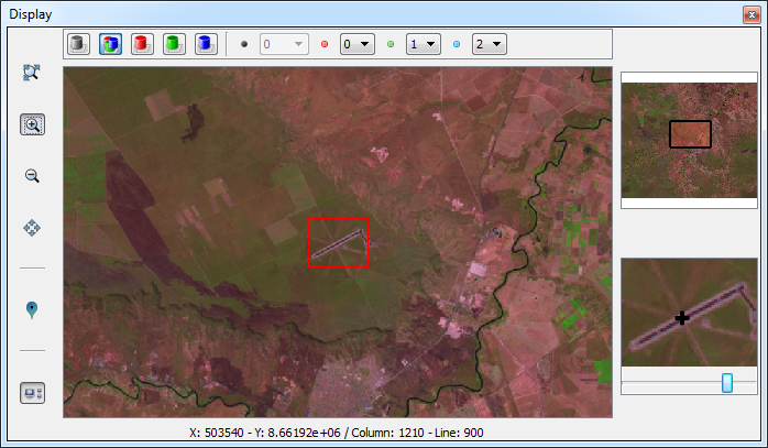
- Green Box: Allows the user to change the color composition of the raster. The set of buttons enables the user to define the color composition desired. Through the combo boxes is allowed to set the values of band for each channel.
- Buttons of color composition:
- Gray
- RGB
- Red
- Green
- Blue
- Combo boxes for band selection:
- Gray Band: index associated to the gray channel.
- Red Band: index associated to the red channel.
- Green Band: index associated to the green channel.
- Blue Band: index associated to the blue channel.
- Red Box: Tools for navigation on the raster.
- Recompose,
- Zoom Area,
- Zoom Out,
- Pan,
- Sample Acquisition,
- Enable/Disable extra displays.
- Orange Box: Extra displays to aid in the visualization of raster.
- Eye Bird: This display always shows the total area of the raster. A rectangle drawn on the display indicates the current display area of the main display.
- Zoom In: This display is the central area of the main display on a larger scale. A slider allows scaling, helping the user to have a higher accuracy to acquire samples.
- Blue Box: Information about the coordinate of the cursor on the raster. Both geographic and matrix coordinates are displayed.
The
extra displays offer some interaction. The interactions made on these
displays has direct effect on the main display.
- Eye Bird:
- Is possible to drag the rectangle that defines the area of the current view to the area of interest.
- Zoom In:
- Changing the scale of view through the slider bar.
- Pan tool is available in this display.