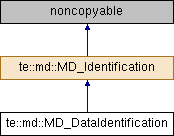
Information required to identify a dataset.
More...
#include <MD_DataIdentification.h>
Information required to identify a dataset.
- Note
- Only the mandatory elements for the core metadata are implemented.
Definition at line 52 of file MD_DataIdentification.h.
◆ MD_DataIdentification()
| te::md::MD_DataIdentification::MD_DataIdentification |
( |
CI_Citation * |
cite, |
|
|
const std::string & |
abstract, |
|
|
MD_ProgressCode |
status, |
|
|
const std::string & |
lang |
|
) |
| |
Constructor.
- Parameters
-
| citation | Pointer to the citation to the resource. Class takes ownership. Do not pass null. |
| abstract | Brief narrative summary of the resource. |
| status | The development phase of the resource. |
| lang | A language used within the dataset. using standard ISO three-letter codes. Do not pass empty. |
◆ ~MD_DataIdentification()
| te::md::MD_DataIdentification::~MD_DataIdentification |
( |
| ) |
|
◆ addCharacterSet()
Adds a character coding standard in the dataset.
◆ addGeographicBBoxExt() [1/2]
| void te::md::MD_DataIdentification::addGeographicBBoxExt |
( |
const double & |
llx, |
|
|
const double & |
lly, |
|
|
const double & |
urx, |
|
|
const double & |
ury, |
|
|
bool |
isInside = true |
|
) |
| |
Adds the spatial description of the dataset.
- Parameters
-
| llx | Westernmost coordinate of the limit of the dataset extent, expressed in longitude in decimal degrees. |
| lly | Southernmost coordinate of the limit of the dataset extent, expressed in latitude in decimal degrees. |
| urx | Easternmost coordinate of the limit of the dataset extent, expressed in longitude in decimal degrees. |
| lly | Northernmost coordinate of the limit of the dataset extent, expressed in latitude in decimal degrees. |
| isInside | True if the bounding polygon encompasses an area covered by the data or false if an area where data is not present. Default true. |
◆ addGeographicBBoxExt() [2/2]
| void te::md::MD_DataIdentification::addGeographicBBoxExt |
( |
const te::gm::Envelope * |
bb, |
|
|
bool |
isInside = true |
|
) |
| |
Adds the spatial description of the dataset.
- Parameters
-
| bbx | Pointer to the enclosing boounding box. Do not pass null. |
| isInside | True if the bounding polygon encompasses an area covered by the data or false if an area where data is not present. Default true. |
◆ addLanguage()
| void te::md::MD_DataIdentification::addLanguage |
( |
const std::string & |
lang | ) |
|
Adds a language used within the dataset.
- Parameters
-
| lang | Language description using standard ISO three-letter codes. Do not pass empty string. |
◆ addPointOfContact()
Adds a point of contact to the resource.
- Parameters
-
| poc | Pointer to a responsible party. Class takes pointer ownership. Do not pass null. |
◆ addTopicCategory()
Adds a theme of the dataset.
◆ clone()
◆ dataIsCovered()
| bool te::md::MD_DataIdentification::dataIsCovered |
( |
| ) |
const |
Returns true if the bounding polygon encompasses an area covered by the data or false if is an area where data is not present.
◆ getAbstract()
| const std::string& te::md::MD_Identification::getAbstract |
( |
| ) |
const |
|
inherited |
Returns the resource abstract.
◆ getCharsetCodes()
| const std::vector<MD_CharacterSetCode>& te::md::MD_DataIdentification::getCharsetCodes |
( |
| ) |
const |
Returns a character coding standard in the dataset.
◆ getCitation()
| const CI_Citation* te::md::MD_Identification::getCitation |
( |
| ) |
const |
|
inherited |
Returns the citation for the metadata.
◆ getExtent()
Returns the set of extents for the dataset.
◆ getLanguages()
| const std::vector<std::string>& te::md::MD_DataIdentification::getLanguages |
( |
| ) |
const |
Returns the set of languages associated to the dataset.
◆ getPointsOfContact()
| const boost::ptr_vector<CI_ResponsibleParty>& te::md::MD_Identification::getPointsOfContact |
( |
| ) |
const |
|
inherited |
Returns the resource points of contact.
◆ getScale()
| long te::md::MD_DataIdentification::getScale |
( |
| ) |
const |
Returns the scale information. If equal to 0 the denominator is not valid.
◆ getSpatialRepTypeCode()
Returns the spatial representation type.
◆ getStatus()
Returns the resource status code.
◆ getTopicCategories()
| const std::vector<MD_TopicCategoryCode>& te::md::MD_DataIdentification::getTopicCategories |
( |
| ) |
const |
Return the themes associated to the dataset.
◆ setScale()
| void te::md::MD_DataIdentification::setScale |
( |
long |
d | ) |
|
Sets resource scale. The scale of a map or other cartographic object expressed as a fraction or ratio which relates unit distance on the map or other cartographic object to distance, measured in the same units, on the ground.
- Parameters
-
| d | The scale denominator. Do not pass <= 0; |
◆ setSpatialRepType()
Sets the spatial representation type.
◆ m_abstract
| std::string te::md::MD_Identification::m_abstract |
|
protectedinherited |
◆ m_charSet
◆ m_citation
◆ m_dataIsCovered
| bool te::md::MD_DataIdentification::m_dataIsCovered |
|
private |
◆ m_extent
◆ m_language
| std::vector<std::string> te::md::MD_DataIdentification::m_language |
|
private |
◆ m_poc
◆ m_scale
| long te::md::MD_DataIdentification::m_scale |
|
private |
◆ m_spatialRepresentationType
◆ m_status
◆ m_topicCategory
The documentation for this class was generated from the following file:

