Generating
Shadow Image
A
shaded image generated from a terrain numeric model will make possible
to view terrain differences in each region. It is
generated from the rectangle grade on which is applied a light model.
This light model determines the reflected light intensity in a
surface point considering a certain light source The model depends on
the light source that can be day light or other light source, and the
surface reflexion.
Azimuth
corresponds to the position of the light source, starting in the South
(Y axis), varying from 0º to 360º, anti-clockwise.
Elevation
corresponds to the angle between the light source and the surface
layer, varying from 0º to 90º.
Height
Exaggeration is the added value in
the surface vertical
scale
in relation to horizontal scale.
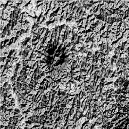
Input regular
grid:
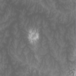
Shaded image
generated:
It is
accessible through:
PROCESSING
→ DTM
PROCESSING
→ SHADOW IMAGE GENERATION...
1.
Select Input
Layer
- Use combobox or
 to select a layer that
contains a rectangle
grid (raster) representation.
to select a layer that
contains a rectangle
grid (raster) representation.
- If the grid has a dummy value , set the checkbox an insert
the value.
2. Image
Style:
- Vmin raster and Vmax raster: Is only to show the original
grid limits;
- Vmin and Vmax: Set the new values of the image limits;
3. Lighting
Parameters:
- Azimuth: set the
value in degrees;
- Elevation: set the value in degrees;
- Height
Exaggeration: set the value in meters;
- Preview: Preview of the output image. Use this button to adjust the lighting parameters before saving the image.
4. Inform
Output Parameters
Resolution X / Y :
grid space.
Dimension C / L
: number of lines and columns.
Note that these values are calculated as they are edited, when
entering resolution the size of the grid is calculated and vice versa.
5. Set
Output SRS

to select output layer SRS.
6.
Inform the Output Repository
by clicking on:
6.1.
to select the output
directory
and also inform the new layer name to store the result, or
6.2. 
to select
the Data Source
and Inform
the new
Layer
Name to store the aggregation result.
7. Click OK
to perform the
operation or Cancel to close the interface.