


Architecture TerraMA²
The system is based on the concept of services (SOA – Service Oriented Architecture), in which a service is an independent functionality, with no state. It accepts one or more requirements, and returns one or more results. Besides the service, there are independent-process modules which export some services and are also able to execute operations in response to a timer (Figure below).
These modules and services use a geographic database for the Exchange of geographic information. Data from the base are stored in TerraLib standard format and include hydrometeorological data, risk plans, and additional information plans necessary to the execution of the analysis and definition of warnings.
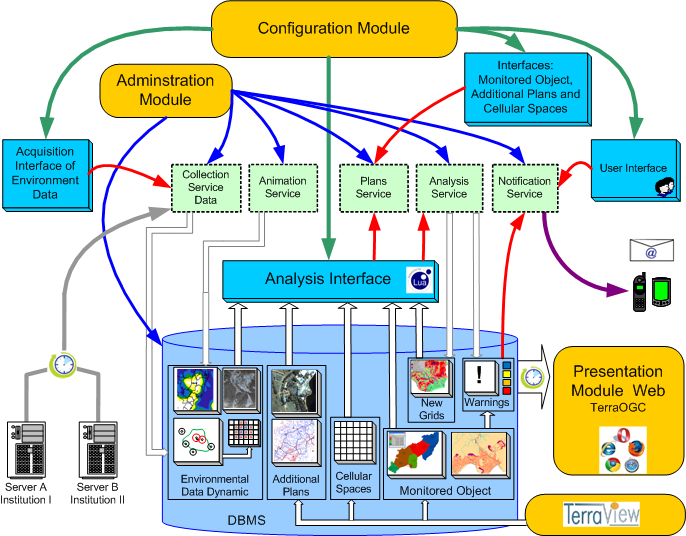
- Configuration Module
It is responsible for enabling the setting of the system. These configurations include how data are obtained from the external servers, analysis definition, and which warnings will be sent.
- Administration Module
It is responsible for enabling the setting of each system service. These configurations include the address and the port of each service, the local the images with the analysis results are stored, the definition of the database, the local where the collected data are stored, the e-mail server setup, the definition of log files, besides other information.
- Presentation Module Web
It is responsible for the presentation of warnings whenever a risk situation is detected by the analysis module. The module consists of a web application which is connected to the TerraLib database. It is capable of presenting layers associated to the analysis, its data, warning record, and metadata.
- Data Collection Service
It is responsible for the acquisition of dynamic geographic data available from remote servers and for searching files periodically. If found, these files are downloaded and included in the geographic database. Data servers and the data location in the servers are configurable.
- Analysis Service
It is responsible for the cross-referencing of hydrometeorological data, risk plans, and additional risks in order to determine the occurrence of alert zones. For each setup analysis which is affected by new data, the respective analysis algorithm is executed. In case new warnings are generated, or a former warning has its levels changed after the analysis, these warnings are saved in the geographical database. Analyses are configurable using LUA programming language.
- Notification Service
It is responsible for sending messages and reports containing information about the changes of the risk levels detected by the analysis module. The users must register as analysis observers so they receive the reports, sent by electronic mail.
- Animation Service
It is responsible for the generation of a set of images that, when grouped, form an animation of data sources of Prediction and Observation. This animation is developed from choosing a data source, a reference layer, and the period of animation. The animation module responds to the requisitions of the presentation interface.
- Plans Services
They execute services for the manipulation of information plans in the geographic data, such as the inclusion of new plans and the listing of existent plans.
Computational Environment
TerraMA² platform runs on computers with Windows or LINUX operating systems, either 32 or 64 bits. The following open source technologies are required:
- Apache (open source HTTP server) and Apache Tomcat (open source implementation of Java Servlet and JavaServer Pages)
- PostgreSQL with PostGIS spatial extension or MySQL Database Management Systems
- TerraView geographic application
- TerraOGC Map server
- Java
Home | Download | Architecture | Documents | News | WEB application | Models | Team | Contact