AMBDATA
Site DPI
Biodiversity Studies
Portuguese Version

   Home
   Data Description
      Origin/Source/Reference
      Geographical Extent/Spatial Scale
      Coordinate System/Datum/Format
   Data
      Climatic Data
      Walsh Index
      Vegetation Map
      MODIS - Percent Tree Cover
      Soil Map
      Altitude
      Slope
      Aspect
      Vertical Distance to the Drainage
      Drainage Density
      Admnistrative Units
   Download
   Useful Links
   References
   Team


Geographical Extent / Spatial Scale

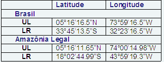
The environmental data were clipped to comprise two spatial boundaries: Brazil and the Brazilian Legal Amazon extensions. The table below presents the respective geographical coordinates.


Some data sources are only available for the Brazilian Legal Amazon.

In the need of another spatial subset, for any specific geographic region, it will be necessary to generate different set of variables.

Click here to access some tips to clip grids.


-