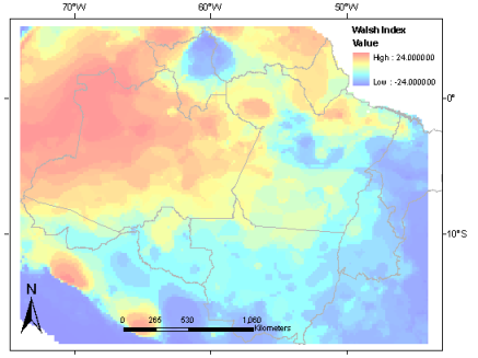
AMBDATA
Site DPI
Biodiversity Studies
Portuguese Version

   Home
   Data Description
      Origin/Source/Reference
      Geographical Extent/Spatial Scale
      Coordinate System/Datum/Format
   Data
      Climatic Data
      Walsh Index
      Vegetation Map
      MODIS - Percent Tree Cover
      Soil Map
      Altitude
      Slope
      Aspect
      Vertical Distance to the Drainage
      Drainage Density
      Admnistrative Units
   Download
   Useful Links
   References
   Team


Walsh Index                       


Walsh index reflects the intensity and length of the dry season (Walsh 1996). The beginning of the dry season is defined when it rains less than 100 mm in a month for the first time in a year (Nelson, personal communication). Professor Bruce Nelson from National Institute for Amazon Research (INPA - Instituto Nacional de Pesquisas da Amazônia) used WorldClim monthly accumulated rainfall (Hijmans et al. 2005) as input data to calculate Walsh Index.
-