|
|
|
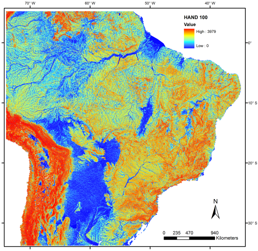
Vertical Distance to the Nearest Drainage

The vertical distance to the nearest drainage is indirectly related to the depth of the water table, which in turn indicates the availability of ground water.
Small values of vertical distance (close to zero) indicate regions where the water table is near the surface and hence the soil is close to saturation.
High values of vertical distance identify regions with deep water table, i.e. well-drained areas.
The grid of vertical distance to the nearest drainage is obtained from HAND algorithm (Height Above the Nearest Drainage) and it is referred to the elevation, or to the vertical distance of each point in relation to the closest drainage.
HAND algorithm (Rennó et al. 2008) considers the unidirectional flow to determine the preferred path of water on the ground to the nearest drainage defined in a Digital Elevation Model (DEM) obtained from the Shuttle Radar Topography Mission (SRTM).
It is necessary to set up a threshold that defines the minimum contribution area from which the drainage begins (springs).
The higher the threshold, the lower the drainage density, i.e. only the main watercourses (higher order) are considered.
Lower thresholds will include smaller drainages, considering a higher number of small watercourses of the drainage network.
HAND Algorithm was implemented at IDL language, using functions of ENVI 4.7 software.
It is available at http://www.dpi.inpe.br/~camilo/hand.
TerraView Users can generate maps of vertical distance to the nearest drainage for other areas and resolutions using TerraHidro software available at http://www.dpi.inpe.br/~alexandre/hidro .
The asc-grid files containing the vertical distance to the nearest drainage was produced from SRTM DEM data, using three thresholds: 50, 100 and 500 pixels. The asc-grid values are expressed in meters.
|
|